Collaborative Laboratory on sanitation, water quality and environmental risk governance
Brazil: Rio Janeiro Metropolitano
Collaborative Laboratory on sanitation, water quality and environmental risk governance
Main contact points:
Romildo Toledo Filho (COPPE, Director), Ana Célia Castro (Futures Institute), Leonardo Mello (Futures Institute): Federal University of Rio de Janeiro, UFRJ, Rio de Janeiro, Brasil
TBD, Instituto Rio Metropolitano, Governo do Estado do Rio de Janeiro, Brasil
The initiative Rio Janeiro Metropolitano considers a collaborative laboratory oriented to the challenges of the metropolitan region of Rio de Janeiro, with emphasis on sanitation, water quality and environmental risk governance.
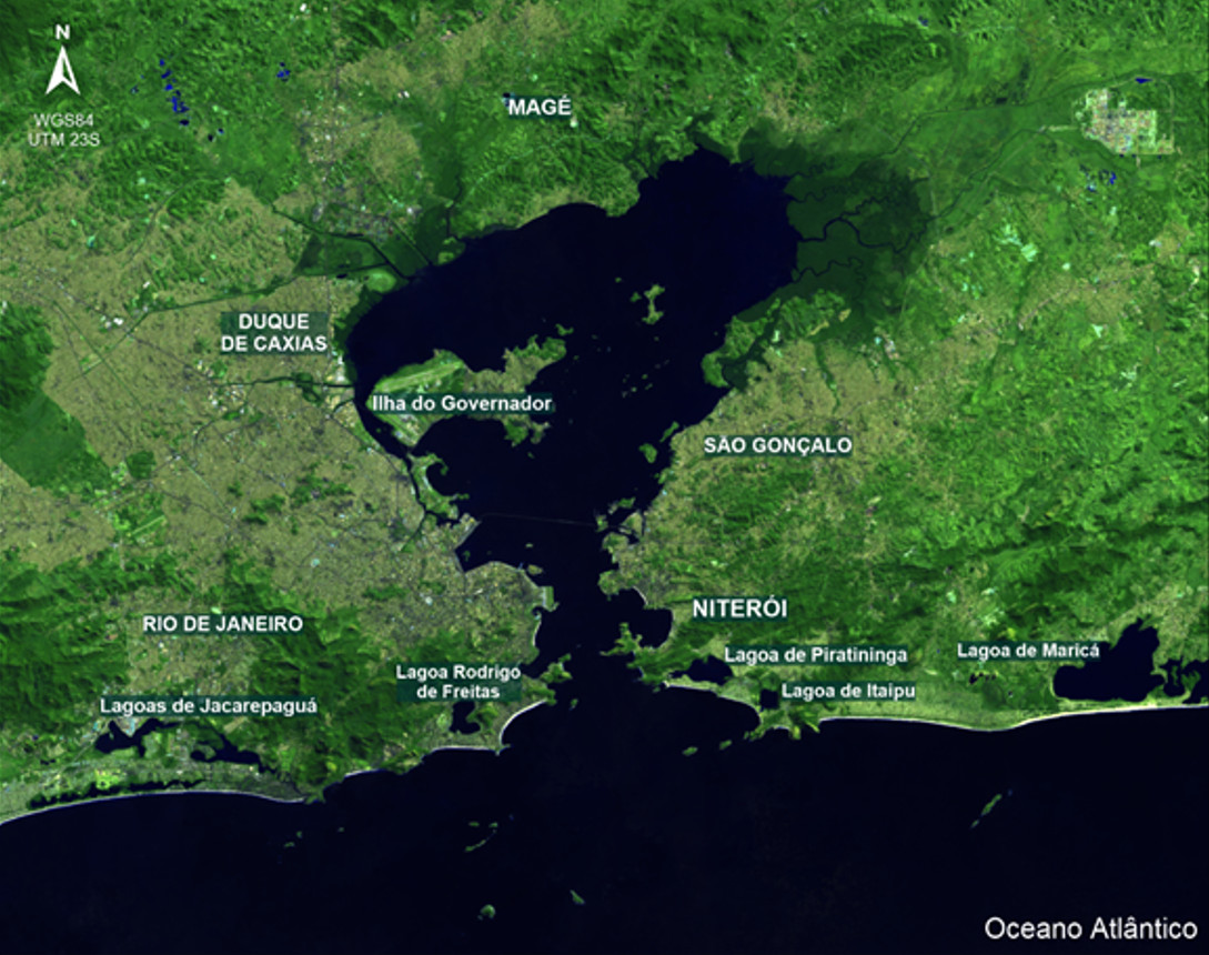
The focus will be on the highly diversified and complex metropolitan area of Rio de Janeiro (with about 7 million people), but considering its complex relationships within the Guanabara Bay, as an oceanic bay in southeastern Brazil, with about 400 km2 and 16 million population.
Emphasis will be on the need to guarantee the access to sanitation and quality water for all, which has been a long-standing process of many decades. Water supply systems in Rio de Janeiro have evolved over time, but still lagging behind: i) Fountains; ii) small local springs; and iii) large systems. This last phase includes the “Guandu System”, as the largest world treatment plant, which remains to work properly in terms of the ultimate goal of providing a quality water system for all.
The ultimate goal is to use advanced data acquisition and processing systems combined with data derived from Earth Observation systems to enable innovative sanitation policies and practices driven by new research dealing with the complex landscape of the water system of Rio de Janeiro.
It should also be noted that Rio de Janeiro is one of the most vulnerable cities in Latin America regarding climate change related impacts [1]. Climate scientists at COPPE/UFRJ and the city’s own planners believe the city’s built environment is at risk of sea level rise, flooding, increased precipitation, and heat islands making large parts of it virtually uninhabitable. Rio de Janeiro’s present climate vulnerability is partly a legacy of its historically chaotic and unequal urban development. After ceding the title of national capital to Brasília in 1960, Rio began to sprawl uncontrollably. Within five decades, the metro area’s population tripled. Population growth exacerbated the shortage of affordable housing and contributed to the steady expansion of unplanned and improvised neighborhoods westward and northward. Informal settlements, or favelas, proliferated alongside waterways and on hillsides./p>
Coastal cities such as Rio de Janeiro need to experiment with different strategies to strengthen climate resilience. There are plenty of ideas out there – including sponge-cities that deploy a combination of repurposed built space, rain gardens, ponds, and wetlands to store excess water, and ambitious eco-restoration projects, such as favela green roofs and green corridors. Nature-based solutions are not just an add-on; they are key to the city’s survival and an on-ramp to sustainable economic renewal.
Under this context, the project aims to leverage existing activities in a myriad of government and non-governmental institutions, to be coordinated through a Collaboratory involving the Municipality of Rio de Janeiro and UFRJ/COPPE, among other partners. It will build on relational infrastructures for collective action, but the main focus will be on building a knowledge-based view of the territory to foster adequate sanitation, water quality and environmental risk governance through a community-based participatory process oriented towards promoting a metropolitan system of innovation and competence building.
It will refer to different levels of analysis and implementation, including infrastructures, access, application and services, content development, and digital skills development. The process considers network societies as wide social and economic processes, occurring across time and space, as it requires the dynamic adaptation of water infrastructures, incentives and institutions, in a way that calls our attention for the need to foster learning societies.
The following main initiatives are planned for the Collaborative Laboratory Rio Janeiro Metropolitano:
Action 1: Ganabara Bay Living Laboratory for Sustainable Development:
The Living Lab has as main goal the development and implementation of an operational digital platform for the provision of environmental, social and economic information in and around the Guanabara Bay region. The diagnostic and prognostic information generated comes from different sources, such as: historical databases, in situ and remote data acquisition platforms and numerical computational models.
In addition to the dissemination of such information, the digital platform also involves extension, technical and academic training activities in different research areas. Such activities allow the continuous operation, development and optimization of the platform involving professionals and students from different educational levels.
The digital platform is public available, allowing both the visualization and acquisition of relevant information for different segments of society that use the region of Guanabara Bay and its surroundings. The project aims to attend demands in different sectors such as: environment, mobility, health, education and others seeking alignment with the UN Sustainable Development Goals.
Data acquisition:
Remote and local data acquisition platforms will be used to monitor in real time the marine and atmospheric conditions of the Guanabara Bay region and its surroundings. Such information, besides being used directly for studies that aim to understand the environmental dynamics of the region, is also used to evaluate the predictions produced by the implemented numerical models. In addition, data of other nature such as social, economic and health will be stored, made available and used for future monitoring of the study region on such aspects.
Environmental Modeling. Atmospheric and oceanic regional models are used to represent temporally and spatially the marine and atmospheric dynamics of the Guanabara Bay region. The models are executed in an operational manner ensuring predictions of up to 48 hours for conditions of surface sea currents, sea level rise, waves, winds, precipitation and other variables for the region of interest. It is intended from the application of data science techniques to use the numerical results generated and the observed data acquired to identify patterns and the consequent development of prediction indices.
Training and Education:
The platform will be developed and improved from the interaction between professionals from different areas of science and students from different educational levels. Such interaction will be based on the development of monographs, dissertations and theses that potentially use the platform for the production of knowledge by investing in the technical and scientific training of researchers. In addition, extension activities involving students from the school segment will be planned in order to promote scientific culture from the knowledge of Guanabara Bay.
Action 2: The SisBaHiA®:
Environmental Hydrodynamics Base System is a system registered by Coppe/UFRJ that can be obtained free of charge through the item “Installation, Training and Support” on the website www.sisbahia.coppe.ufrj.br.
The SisBaHiA® has been expanded and improved at Coppe/UFRJ since 1987, through several master's dissertations and doctoral theses, in addition to many research projects. The system has already been adopted in hundreds of studies and projects involving modeling of natural water bodies, including several on the coast of Rio de Janeiro and specifically in Guanabara Bay. The analyzes include modeling with mean values in the water column (2DH) in the Guanabara Bay and adjacent coastal zone coupled with one-dimensional modeling (1D) in the tributary watersheds. Validated models, that is, calibrated and verified with field data and analyzed by experts, are indispensable tools for studies and projects, for the management and management of natural water bodies, as they allow: diagnostic analyzes and prognostic analyzes.
Action 3: The Guanabara Bay Observatory
This observatory aims to form a pole agglutination and radiator of technical knowledge and scientific with a view to the continued recovery of Guanabara Bay and its basins contributing river basins, in support of the environmental agencies, regulatory agencies, the Committee on Basin and NGOs operating in the region.
Using the water monitoring quality and of the Guanabara Bay biota and contributing watersheds, with the use of techniques and technologies to detection, quantification and biodiversity documentation aquatic, with an emphasis on imaging underwater in areas of high turbidity, in underwater photogrammetry in hydroacoustics, and in the use of environmental DNA (eDNA).
Development of hydrological models and water quality for process simulations of eutrophication caused by launch of loads organics and nutrients in rivers and in the bay of Guanabara. The main objectives of the Guanabara Bay Observatory include: Production and availability of scientific information for opinion public, NGOs, environmental bodies and regulatory agencies, institutions of research and the press in general about the environmental situation of BG; Continuous monitoring on the status of the BG; Governance: Support for the water resources management system conducted by the Guanabara Bay Hydrographic Region Committee and Lagoon Systems of Maricá and Jacarepaguá; Disclosure of data with autonomy and exemption.
[1] See, for example, https://foreignpolicy.com/2021/03/27/rio-de-janeiro-natural-disasters-climate-change-urban-planning-adaptation/